Hurricane Lee update: Hurricane expected to regain strength as Category 3 storm spins way from East Coast – latest

Hurricane Lee downgraded to Category 3
After exploding from a Category 1 to a Category 5 storm within 24 hours last week, Hurricane Lee has downgraded to a Category 3 storm, though forecasters predict the storm could regain strength as it whirls across the open Atlantic Ocean in the coming days.
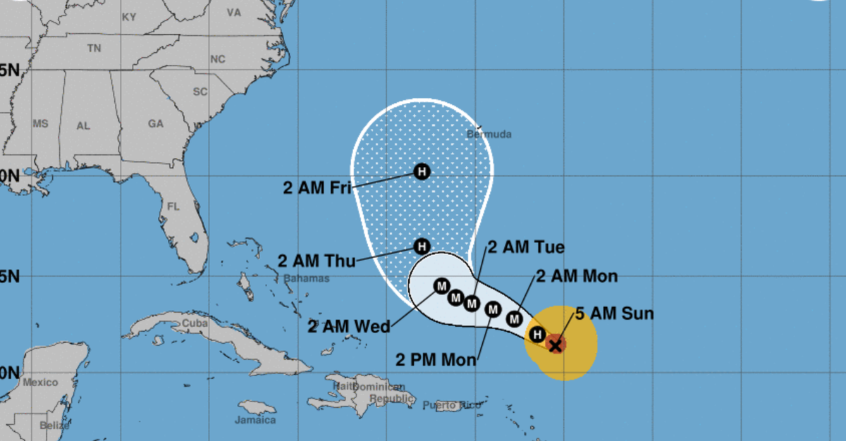
Lee is “slowing down” as it moves well north of Puerto Rico, the Virgin Islands and the northern Leeward Islands, though it still remains too early to determine its course and whether the northeastern US coast and Canada could see any impacts, according to an advisory from the National Hurricane Center on 10 September.
But life-threatening surf and rip conditions are expected along the East Coast, while dangerous swells generated by the storm are spreading to the Virgin Islands, Puerto Rico, Hispaniola, the Turks and Caicos Islands, the Bahamas, and Bermuda.
Lee’s historic intensification from an 80 mph Category 1 to a Category 5 with 160 mph winds last week makes it one the fastest-intensifying Atlantic storms on record. Warm waters are a potent fuel for hurricanes to gain strength, a phenomenon expected to accelerate amid a growing climate crisis.
Latest Lee update: Storm is ‘slowing down’ and likely regaining strength as it steers north
After it was downgraded from a Category 3 storm, Hurricane Lee is predicted to regain strength as it travels along warm Atlantic waters in the coming days.
Lee is “slowing down” as it moves well north of Puerto Rico, the Virgin Islands and the northern Leeward Islands, though it still remains too early to determine its course and whether the northeastern US coast and Canada could see any impacts, according to an advisory from the National Hurricane Center on 10 September.
But life-threatening surf and rip conditions are expected along the East Coast, while dangerous swells generated by the storm are spreading to the Virgin Islands, Puerto Rico, Hispaniola, the Turks and Caicos Islands, the Bahamas, and Bermuda.
Alex Woodward10 September 2023 14:30
Will Lee and Margot collide in the Atlantic?
Newly formed Tropical Storm Margot is expected to grow into a hurricane next week, raising the possibility that it could mingle or alter Hurricane Lee’s path, though it is still far too soon to project whether the two major storms could get close to one another any time soon in the Atlantic Ocean.
Such a phenomenon, when two storms rotate around each other and spin in the same direction, is called the Fujiwhara effect. The National Weather Service describes it as “an intense dance around their common center.”
That could then push them both around the Atlantic and alter their paths.
The phenomenon occured with hurricanes Hilary and Irwin in the East Pacific in 2017.
Alex Woodward10 September 2023 11:00
‘Rapid intensification’ of storms likely to accelerate with warming waters
Hurricane Lee is in rare company. Only two recorded storms – Hurricane Wilma in 2005 and Hurricane Felix in 2007 – strengthened faster than Lee over a 24-hour period, as Lee developed from a Cat 1 to a Cat 5 last week before degrading into its current Cat 3 status.
Brian McNoldy with the University of Miami told NBC News that the warm conditions in the Atlantic were ripe for the storm’s rapid intensification.
The “vertical wind shear was very low and the water temperature under it was very warm,” he said, adding that Lee “took full advantage of both.”
Warm waters are a potent fuel for hurricanes to gain strength, a phenomenon likely to accelerate amid a growing climate crisis and warming waters.
Last year, Hurricane Ian rapidly intensified over two separate periods before striking Florida. Hurricane Idalia recently strengthened from a Cat 1 to a Cat 4 within 24 hours.
“It’s a huge problem, and the past is not a good guide to what we should expect going forward,” Jeff Masters, a former hurricane scientist with the National Oceanic and Atmospheric Administration, told NBC.
Hurricane Lee is pictured by NOAA satellite in the Atlantic Ocean on 8 September.
(AP)
Alex Woodward10 September 2023 09:00
Why Lee is blowing meteorologists’ minds before it even makes landfall
The first Category 5 storm of the Atlantic hurricane season didn’t stay that way very long, but Hurricane Lee’s rapid intensification from a Category 1 into a Category 5 within 24 hours from Thursday into Friday is likely a record-breaking event in modern meteorological history.
The storm then degraded into a Cat 4 then a Cat 3, though it is likely to gather strength as it moves northeast.
Cat 5 storms already are rare, but inreasingly more common, relative to the history books. According to University of Miami hurricane expert Brian McNoldy, roughly 4 per cent of named storms in the Atlantic basin have reached that threshold since the early 1920s.
Lee’s intensification from an 80 mph Cat 1 to a Cat 5 with 160 mph winds has likely made it the fastest-intensifying Atlantic storm on record.
Not only that, for the first time on record, Cat 5 storms have formed in every tropical ocean basin within one year.
Alex Woodward10 September 2023 07:00
FEMA stocks up food and water for potential Puerto Rico and US Virgin Islands response
The USS Federal Emergency Management Agency has roughly 4.5 million meals and nearly 8.9 million liters of water in Puerto Rico as Hurricane Lee rears eastward as a powerful Category 3 storm that could gain strength over the weekend.
The storm is not yet predicted to make landfall, if it does at all, but emergency responders and national weather agencies are keeping a close watch.
Roughly 250,000 meals and more than 600,000 liters of water are prepared to support the US Virgin Islands, FEMA also announced on Friday.
Alex Woodward10 September 2023 03:00
‘A major wave producer’
It still remains far too early to tell what Lee will look like for the East Coast as it creeps along a northeastern track, but forecasters predict high seas and rip currents up and down the Eastern Seaboard.
“What we are going to see from Lee – and we’re very confident – is it’s going to be a major wave producer,” National Hurricane Center director Mike Brennan said in a Friday briefing.
On Saturday, large swells battered the northeast Caribbean as Lee churned through open waters hundreds of miles off the northern Leeward Islands, the Associated Press reported.
The highest waves recorded by the center were at about 45 and 50 feet, and the “highest waves could even be double that,” Mr Brennan said.
“So we could be looking at 80-, 90-foot waves associated with Lee,” he added.
A satellite image from NOAA shows Category 3 Hurricane Lee in the Atlanic Oean on 9 September.
(NOAA/GOES/AFP via Getty Images)
Alex Woodward10 September 2023 01:00
How close will Lee get to the US?
Exactly when or how Lee will travel northeast is still too early to tell. What happens next is up to a combination of atmospheric factors, including an area of high pressure in the Atlantic Ocean and a jet stream to its west.
That area of high pressure is likely to play a major role in Lee’s track, and is expected to keep Lee on its current west-northwestward path over the weekend. That scenario would keep the storm rotating out to sea, or send it closer to Bermuda.
The storm is still roughly one week from posing a potential threat to the East Coast of the US, if it poses any at all.
Alex Woodward9 September 2023 23:00
Latest Lee advisory: Hurricane expected to pass north of Leeward Islands while generating dangerous waves over weekend
Hurricane Lee, still a Category 3 storm, is expected to pass “pass well to the north of the northern Leeward Islands, the Virgin Islands, and Puerto Rico into early next week,” according to an afternoon advisory from the National Hurricane Center.
Maximum sustained winds are near 115 mph with higher gusts, and gradual “restrengthening” is possible during the next couple of days, the center predicts.
Swells generated by Lee are affecting portions of the Lesser Antilles and will spread westward to the British and US Virgin Islands, Puerto Rico, Hispaniola, the Turks and Caicos Islands, the Bahamas, and Bermuda through the weekend. Those swells are “likely to cause life-threatening surf and rip current conditions,” according to the report.
“Dangerous surf and rip currents” are also expected along the US East Coast on Sunday and Monday and then worsen through the week.
Alex Woodward9 September 2023 22:10
Too soon to tell but too soon to rule out significant impacts, forecasters say
Hurricane Lee was significantly disrupted by wind shear within the 24 hours after it accelerated into a Category 5 hurricane, as it then degraded into a Category 4 then Category 3 into Saturday morning.
Models are suggesting that the shear will subside by Sunday morning, which could allow Lee to gain more strength as it continues to track east, according to Levi Cowan with Joint Typhoon Warning Center.
“Regardless of Lee’s exact intensity, it will be a major hurricane tracking north of the Caribbean and then turning northward over the western Atlantic over the next week,” he said.
“It remains too soon to rule out impacts from Lee” as models predict it could track forwards Bermuda, Canada and the northeastern US, he added.
Alex Woodward9 September 2023 22:00
Lee shattered ‘rapid intensification’ standards, a warning of future storms amid growing climate crisis
Hurricane Lee’s acceleration from an 80 mph Cat 1 to a Cat 5 with 160 mph winds within 24 hours has surpassed the standards meteorologists typically associate with “rapid intensification,” or when winds increase by 35 mph within that same time period.
It not only makes Lee the fastest-intensifying Atlantic storm on record, it has set a new threshold that scientists see as a potential harbinger for what’s to come as the climate crisis accelerates.
“This one increased by 80 mph,” Marshall Shepherd, director of the University of Georgia’s Atmospheric Sciences Program and a past president of the American Meteorological Society told the Associated Press. “I can’t emphasize this enough – we used to have this metric of 35 mph, and here’s a storm that did twice that amount and we’re seeing that happen more frequently.”
Alex Woodward9 September 2023 21:02
xnxx,
xvideos,
porn,
porn,
xnxx,
Phim sex,
mp3 download,
sex 4K,
Straka Pga,
gay teen porn,
Hentai haven,
free Hentai,
xnxx,
xvideos,
porn,
porn,
xnxx,
Phim sex,
mp3 download,
sex 4K,
Straka Pga,
gay teen porn,
Hentai haven,
free Hentai,

")
)")

